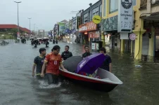
Malaysian forecasters have warned that flooding will affect multiple communities in the Tumpat district as river levels approach hazardous thresholds. The National Flood Forecasting and Warning Centre identified vulnerable zones along Sungai Kelantan and Sungai Golok, with predictions indicating inundation beginning within days.
Low-elevation settlements within five kilometers of both waterways face heightened risk, encompassing Padang Rokma, Bechah Temalang, Chenderong Batu, Kampung Kok Kebit, and Taman Sri Bayu. Additional threatened villages stretch along Sungai Golok's floodplain, spanning from Kampung Pak Keral through Simpangan.
Authorities directed inhabitants to monitor official channels for updates while following directives from emergency management agencies during the anticipated high-water period.