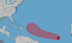
A tropical system in the central Atlantic may strengthen into a depression as it moves westward toward the Leeward Islands, the National Hurricane Center reported on Sunday. The low-pressure area sits several hundred miles southwest of the Cabo Verde Islands and produces disorganized storms across favorable conditions for development. The system would receive the name Jerry if it intensifies into the season's next named storm.
The disturbance follows recent interactions between hurricanes Imelda and Humberto through a Fujiwhara effect, where two rotating storms orbit a shared center. Humberto reached Category 5 intensity with 160 mph winds before dissipating after merging with a frontal boundary, while Imelda peaked as a Category 2 storm and struck Bermuda with 100 mph winds. Neither hurricane made U.S. landfall, but their swells destroyed at least nine homes along North Carolina's Outer Banks. The Atlantic has generated four hurricanes this season, with two reaching Category 5 strength.
The disturbance follows recent interactions between hurricanes Imelda and Humberto through a Fujiwhara effect, where two rotating storms orbit a shared center. Humberto reached Category 5 intensity with 160 mph winds before dissipating after merging with a frontal boundary, while Imelda peaked as a Category 2 storm and struck Bermuda with 100 mph winds. Neither hurricane made U.S. landfall, but their swells destroyed at least nine homes along North Carolina's Outer Banks. The Atlantic has generated four hurricanes this season, with two reaching Category 5 strength.